Sunday, 11 May 2014

Round Valley Draw to Hackberry Canyon

5th May Round Valley Draw to Hackberry Canyon 14 miles
Escalante is a small town but has all the facilities we needed; post office, grocery store, thrift shop, gear shops and some nice eateries. We had a good rest up here and after much deliberation, decide to hitch forward around the next section of the Hayduke to start hiking again from near Grosvenor Arch. This allowed us to have a shorter hike next where we could carry less food (four days) whilst allowing us to add in some interesting side trips including Yellow Rock and Bull Valley Gorge.

On the 5th we headed out of town. Breakfast first sitting outside our motel room, then we packed up and posted our 'float box' of extras to the town of Kanab, a couple of weeks of hiking away.

We waited for about 30 minutes at the edge of town before we got a hitch from Mario who worked in the building trade in Escalante and gave us some of his wife's delicious cactus salad! He dropped us of in the tiny town of Cannonville. As we aimed to hike back through here in 4 days, we arranged to leave a food package for the next 4 days so that we can save weight whilst hiking.
Cactus salad!


Cannonville is still around 20 miles by dirt road from our re-connection with the Hayduke but we just headed off hiking south on 'Cottonwood Canyon Road'. We soon got another lift from a very friendly and chatty German couple in an RV along a dirt road for a few miles (there is some traffic here heading to Kodachrome Basin State Park and the Arch). Eventually at midday we reached Round Valley Draw trailhead near Grosvenor Arch. It's pretty around here in an open sagebrush landscape but with sweeping Ponderosa pine trees and white and pink Navajo sandstone cliff faces.

After our cactus salad lunch we headed down south towards the slot canyon of Round Valley Draw. This was an amazing place, the land just opens up into a slot which we could squeeze down for about 20 feet to the floor of the canyon. We loved it! We needed to hand down our backpacks in a few places to squeeze through and jammed logs showed the power of flash floods.
Dropping down into Round valley Draw slot canyon


Down!


Flood debris in Round Valley Draw slot canyon


From there we traveled down the wider and sandy Hackberry Canyon where eventually we found water (shared with lots of tadpoles which you can see in the pic) and lush cottonwood trees. 

(Explanation of "Shackleton": our 4 two liter water bags are named for polar explorers so we can distinguish them when we carry treated and untreated water - we also have Nansen, Franklin and Tillman with us).
Hackberry Canyon

Hot sandy floor of the canyon

Our tadpole water source

Camp in Hackberry Canyon


Sunday, 4 May 2014

Escalante!

Wow that was a wild, tough but beautiful hike!
Have reached the small western town of Escalante last night after 7 days out there.
We climbed into the Henry mountains and got snowed on then descended in wonderful Capitol Reef national park before weaving through the canyons of Escalante national monument through world class scenery. Now recovering in town after demolishing a 16" pizza and pitcher of excellent Wasatch brewery beer. Oh met one other hayduke hiker in town..  Micheal Geiss from Munich! Details to follow in the next post.........


Into the Escalante canyons

May 1st Halls Creek to lower Steven's Canyon 15.5 miles
Our first aid flowchart


From our camp we crossed the river through thick riparian vegetation to the west side and scrambled our way onto Navajo slickrock slabs. A cairn was found-excellent, we hoped this was the historic Baker Trail and would lead us upwards out of Halls Creek and into the Stevens Canyon watershed.

Hiking up the slabs was superb with views opening out back to the Henry mountains again- already showing signs of snow melt since we crossed them a few days ago. Dammed Lake Powell (or Lake Foul as Li Brannfors had named it on his maps) appeared now to the south east, its low water levels revealing expanses of unnatural scrub plains.
Climbing out of Halls Creek on slickrock


We soon lost the cairns and headed up south west. The terrain was complex though- domes of slickrock sometimes dropping steeply requiring some backtracking to weave a reasonable line up to the top. Occasionally we found another cairn but couldn't see any continuation of the route so we just navigated our own way.


At the summit we had a short rest then descended south west looking for a way into Stevens Canyon. The top of Stevens has many steep 'fingers' and there was no sign of a route so we just picked a 'finger' and scrabbled down slabs using junipers for holds until we popped out into what looked like the main canyon.

Eventually we made it onto an easier beautiful wash bottom with lots of pink towers and steep canyon walls. Awwhhh, this was brilliant hiking down slabs with sensually sculpted potholes of water like a 'string of pearls'.

The upper canyon had a real wild feel so we were surprised to meet 3 hikers coming up canyon. We exchanged navigation and water notes and this gave us encouragement that there was a way through down Stevens to the Escalante river (we did have doubts!).

Looking west down upper Stevens Canyon
Sometimes we would be hiking the canyon bottom but we alternated to following the canyon sides on amazing slick rock shelves. On one of these we had to scramble over a boulder field sitting on the slab. Brian hopped off a freezer sized boulder onto the ground below between other rocks. The boulder rolled towards him just about pinning him against another rock but luckily jammed itself in. He was left with various gashes to thighs and arm. Martina emptied our somewhat frugal first aid kit and, along with duct tape and some spare clothing managed to patch Brian up. Even more luckily for him his injuries were just scrapes and bleeding rather than muscular or any bones and he could still hike, albeit a bit wobbly for the first hour or so!

Lower down in Stevens the hiking is through more densely vegetated canyon bottom with some wading through deep water pockets. Poison ivy made an appearance as well and was quite hard to avoid. About a mile short of the junction with the main Escalante river we found a marvelous camp next to a garage sized boulder serenaded by croaking frogs through the evening!

Despite the boulder incident it was a fantastic day through the best of scenery with varied challenging hiking. Some more images below.....

Lots of potholes with water in Stevens Canyon
Stevens Canyon 

Cold water dip in Stevens
Our wonderful camp in lower Stevens Canyon
2nd May Stevens to Hurricane Wash 16 miles (plus hitch into Escalante)
We aimed to make it to town today and were off at 7 am (early for us) in lovely early morning canyon light. Our canyon emptied into the larger Escalante and we follow this downstream for 1.5 miles or so. The water seemed to be running quite high with much thigh deep wading and the water temperature is COLD! Stunning hiking though in this world class area. The reflected light on the striped uniform sandstone cliffs is a sight to behold.

We passed 3 hikers sleeping in bivvy bags under Stevens Arch indicating to us that we were entering the popular Coyote Gulch area. Turning into Coyote Gulch itself we found it had quite a strong water flow and we had a rest to warm our feet up and change into dry socks.

Coyote is popular for a reason, as it has splendid scenery- mixing flowing water, lush green vegetation, awesome canyon walls and many natural rock arches. We kept to a fairly fast pace though, winding our way up the canyon hoping to make it to the Hurricane Wash trailhead dirt road by early afternoon to give us a chance to find a lift back the 30 miles or so to the town of Escalante.

The day heated up but the mix of shade and sun was ideal for us. Passing by campers at Jacob Hamblin Arch we looked up to see the scrambling route up the arches rib we had taken when last here in 2004.

Stopped to watch a raven returning to feed chattering chicks on a high rock ledge. Swirling fluff from the cottonwoods added a surreal edge to the day.

We exited out into Hurricane Wash which was smaller and pleasant but soon opened out into a dry, sandy, exposed hike to the trailhead.  Reaching the dirt road where we hoped to hitch, it was hot and windy and most disappointingly there were very few cars there! We hung around for an hour or so but lucked out as a hiker returned to his car and agreed to give us a ride to Escalante- hoorah!

In town, all the motel rooms were booked out for the night, so we camped at Escalante Outfitters and booked a motel room for the next night. Both of us were a bit tired, dirty and sore, so a rest was in order. After a shower we had a huge pizza and beer at the outfitters and met Micheal Geiss, the other Hayduke hiker we had heard of- the first we have met. It was nice to relax and exchange tales of our hikes from the last few weeks!
Wading the Escalante

Looking up to Stevens Arch
Starting up Coyote Gulch


Coyote Arch
Hot, dry and dusty hitching next to the dirt track

Capitol Reef National Park

April 29th Swap Canyon to Muley Tanks 20 miles
An epic and great day...
We had a pleasant start down Swap Canyon on a meandering gravel wash surface. It was cold and windy but warm when the sun hit us. After an hour or so we emerged out of the canyon into colourful views of the waterpocket fold and its multiple pinnacles of rock.

What happens here is that all the colourful layers of sandstone that are usually horizontally stacked on top of one another have tilted upwards. The plateau we were moving over is sloping up. Erosion creates deep canyons full of colour and reflected light- like 'sleeping rainbows'. After the snow and rain from the past days the desert was blooming. Temperatures were still mild and a fresh wind blew us gently along.
Approaching the waterpocket fold
Our route took us onto the dirt road of the Burr trail which zig zagged upwards under huge sandstone walls. Expansive views opened up eastwards back the way we had come to the Henry Mountains.
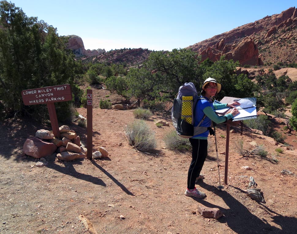
At the top we hit Capital Reef National Park, the Lower Muley Twist Trailhead and signed the trail register. Surprisingly we saw that another Hayduke hiker had been here two days ago- Micheal Geiss. 
Since we hadn't met any other long distance hikers yet (and hardly any other hikers at all) we looked forward to seeing if we could meet him - perhaps in our next intended town stop of Escalante.

We did meet an English couple staying in Calgary a few minutes into the canyon though and enjoyed a chat with them, before we headed between the amazing sculpted sheer rock walls of Lower Muley Twist.
Further on the twisting canyon had some fantastic deep alcoves (or alcaves as we called them) -bigger than we had ever seen. The 8 miles down the canyon were tremendous with lots of variety overall.

We stopped at 'Cowboy Alcove' - complete with some old food tins and graffiti- for a break before the canyon dropped east through lovely narrows and exited out into the wide expanse of Halls Creek.
Cowboy Alcove
Here the canyon was less dramatic but still scenic with maroon wingate sandstone domes. Our destination was some huge pools of water called Muley Tanks lying a few hundred meters west of the canyon bottom. We struggled to find them though, and had to double back and search around for them. It was worth it though as the pools sit in an idyllic spot on sandstone slickrock. Our feet were sore but it was a great end to the day and we set up camp a few hundred meters away under a juniper tree.
Sun setting at Muley Tanks
Deep alcoves in Lower Muley Twist
April 30th Muley Tanks to south end of Halls Creek 20 miles
After studying our maps we decided to divert from the Hayduke route again and take an alternate down Halls Creek and Stevens Canyon over the next 2-3 days. It looked scenically fantastic in Stevens (we had visited the lower part of the canyon in 2004) and the alternate would avoid the normal Hayduke route's.long 25 mile wade down the Escalante river.

Halls Creek was initially dry and sandy and was wide open in complete contrast to yesterday's narrow canyon. The going was fairly good - a gravelly sandy base- and the views were ever changing. We found a single track trail on the east side of the wash that took a more direct line than the meandering river for much of the way.
Halls Creek

It also took us through some of the loveliest desert flowers we have seen! Pink cactus, yellow lillies, purple lupins, white primrose, some orange flowers, sages- contrasting with a deep red soil.
Quicksand shoes
Further south, water surfaced and into the afternoon we hit thicker scrub and bushwhacked through bamboo like willow and other tangled vegetation. We resorted to just hiking down the river for a while and some spots of quicksand kept us alert! The quicksand we came across wasn't particularly dangerous especially with a partner to help pull the victim out! Once you emerge from the quicksand you end up with thick clinging goo over your shoes and socks though which can be hard to clean off.
Our campsite was beside the river in halls Creek nestled against a red sandstone dome, about 2 miles short of where we aim to climb out of the valley over into Stevens Canyon via a disused route called the Baker Trail. One of the tent zippers  at the front failed probably due to the excessive sandy, dry conditions- bummer (we have a otherwise wonderful Terra Nova Voyager)!

Saturday, 3 May 2014

The Henry mountains and Tarantula Mesa

April 26th Poison Spring H95 to Crescent Creek 10.5 miles
The temperature dipped and it poured down as we tried to hitch out of the tiny town of Hanksville 17 miles back to where we left our hike. We soon gave up hitching and retreated back to Stan's diner for some mid morning coffee. That then turned to lunch!! Luckily the skies brightened a bit after lunch and we finally got a lift from two guys driving down to Lake Powell to repair their boat.

Loaded up with 9 days food for this long stretch to Escalante, we took it slowly, but there were great views upwards to the snowy mountains and back to the extensive plains to the east. After navigating around Butler Wash we headed back up on jeep tracks in pinyon juniper before hitting tall ponderosa pine and ghostly white aspen. 
Ascending into the Henry mountains


Some cobalt blue bluebirds fluttered around in the trees. We hiked on a big muddy dirt road from recent active mine workings and were glad to escape from it to find a pleasant grassy camp site near Crescent Creek nestled amongst aspen. Five wild turkeys strutted past and disappeared into the bush.

We enjoyed a wonderful burrito and taco from town for dinner as we listened to the drumming of hail on the tent outer as well as the sound of thunderstorms. We read about Norwegian explorer Nansen's polar exploration though and our little bit of cold weather seems like nothing compared with his hardships!
Camp in snow amidst aspen beneath the Henry mountains

April 27th Crescent Creek to Tarantula Mesa 21 miles
Nice day. We awoke to a white snowy scene in the morning. There was wild, windy, cold weather above the cover of our aspens and we chose reluctantly to bypass the Hayduke route over the south summit of Mount Ellen by skirting the mountain to the south and west on jeep tracks.

It was rather lovely though with crisp air and woodpeckers rat-tat-tatting in the trees. At Copper Ridge we tried to head back west onto the mountain ridge but were beaten back due to high winds and biting hail and spin-drift. Oh well another time -we simply didn't have enough clothing to withstand that sort of weather! 

As we circled the mountain, the temperature increased a little and the jeep track turned into gloopy, gooey mud making for tricky going. Our high point was about 9,200 feet before we started to descend onto the northern slopes of the Henry mountains.


Lunch was at the sunny, grassy meadow of Airplane Spring at 7,665 feet which made for a warm pleasant stop. We relaxed near the memorial plaque for a crashed airplane here with its dry water spigot. However we found water eventually about 300m down (westwards) the track in a trough.

From here we descended further into drier mesa country on more dirt roads to meet up with the Hayduke again. There were a couple of steep climbs but the track generally meandered easily south west. The mesa is a shelf sloping gently down westwards before dropping over a couple of cliff bands to the Waterpocket fold -our destination tomorrow hopefully-which looked great ahead. Views back to the sparkling snowy Henry's were impressive too.

The 7 mile dirt road of Tarantula Mesa wore both of us out a bit and we are glad to reach the second of two solar panel water troughs in the evening to pick up water and camp a few hundred meters away amongst juniper for shelter.
Collecting water on Tarantula Mesa

Camp on Tarantula Mesa

April 28th Tarantula Mesa to Swap Canyon 11 miles

We woke up to cold wind and clear air. Today we are due to drop into wild country with some tricky navigation down through cliff bands and complex canyons. After a short dirt track we headed cross country through the juniper looking for the cliff edge drop off. We were pleased to pick up some welcome cairns at the top of the cliff and then scrambled steeply downwards on ledges and rock. 
Above the drop down from Tarantula Mesa 


After a traverse left we dropped down a dusty rubble chute to the canyon bottom made of soft bubbly clay.The going was easier for a while along the Muley Creek's dry gulch bottom before we headed into tremendous arid country south west across undulating benches. We ground to a halt trying to find a trail on our map and had to retrace our steps and resorted to the GPS for a bit before picking up the faint path traversing benches.
Below the Tarantula Mesa first cliff band


Another gulch with some wicked quicksand(!) wound its way down towards surface water amongst thick reeds at a canyon junction. We had a fair amount of drinking water left from last night and decided not to bother with the fairly cow infested water here abouts. 

We stopped for lunch in the shade of a cottonwood near the water though with hummingbirds zinging around and a dead buffalo which added to the scene.
The Hayduke route takes a loop north west and then south from here and we chose to take a more direct but interesting alternate described by Nicolas C. Barth called Below Tarantula 2

We passed what looked like a coal seam and followed some dry drainage's upwards before a steep scrabble back to meet up with the Hayduke route (although the Hayduke itself is also cross country here!). 

More complex rocky terrain followed before we found another key scrambling descent with the odd cairn into Swap Canyon. From here we had easy navigation down the wide gulch to a pool of water which looked like a good stopping point. Although it was early at 4.30 we were able to have a clean and it meant that we could hike tomorrow to the next water source at Muley Tanks 19.5 miles away without carrying overnight water.

Friday, 25 April 2014

The Colorado to Hanksville


20th April Spanish Bottom to Lou's Spring 12 miles
We left the boats behind at Spanish Bottom in Canyonlands National Park. Our plan is to hike on for 4-5 days roughly westward through desert and sandstone country to a highway where we aim to hitchhike into the small town of Hanksville for supplies. In the Utah desert lots of comparatively small geological or landscape features have been given names by white explorers and cattle ranchers and our hike was a sort of micro navigation from one such feature to the next.

It sounded a bit like an itinerary from middle earth......
From Spanish Bottom to the Dolls House, over Ernie's Flats past the Fins up Sweet Alice Canyon to Lou's Spring. Climb the Golden Stair  - past 'Mother and Child' Rock - over a plateau to the Flint Road. Down into Happy Canyon, through the narrows to cross the Dirty Devil river, then up to Poison Spring Canyon to the highway.

We had a nice relaxed morning beside the Colorado sorting the gear out in the shade. Our pick up boat arrived around 12.30 from Moab and they made short work of pulling our kayaks onto the boat and taking our kayak rental gear, toilet(!) and garbage bag away with them. Soon we are alone, just us and our backpacks. It's got hot (high 20's C) and we were motivated to camp at a water supply 12 miles away so we set off quickly up the steep slopes above the Colorado.
Our kayaks are collected

Heading above the Colorado to Dolls House

There was a trail to follow uphill which made the hot climb easier. We reached the Dolls House - an area of superb sandstone towers with a campsite reachable by a long dirt road, and we saw some people here. We picked up a faint trail through pinyon juniper out onto Main Flat, a sandy plain surrounded by pink pinnacles. The sand made for tough walking but we loved getting back into hiking and soaking up the views.
Main Flat
Our route weaved it's way through lovely rock garden scenery to near Clells Spring, which we don't visit, but we do spot a couple of pools of water here that we could have drawn from. We are aiming for Lou's Spring though further on which is supposed to be a good water source. After some rockier terrain we made it to the spring in late evening and were glad to find clear water in a tank fed by a dripping pipe. Martina spotted a hummingbird here.

We camped on a good flat spot on top of a sandy hillock, a few hundred meters away from the spring itself. Some spots of rain but the sky cleared as it got dark around 8.30 pm. A great day!

Heading west away from Doll's House
Lou's Spring
21st April Lou's Spring to Happy Canyon south fork 20 miles
We woke at 6 am as it got light and fetched some more water from the spring before heading out with 5 liters each as we were not sure where our next water would be. The tent is frosty but the heat soon builds up as we climbed slick rock out of the canyon and are bathed in red light from the sunrise. After crossing some jeep tracks we headed uphill through another cliff band on the Golden Stairs trail. This traverses across the cliffs finding a line of weakness up onto a higher plateau area via a neck of rock to another jeep track trailhead.

Here we met Tom who is 70 and is heading out into Ernies Country (where we have just come from) for 2 days. We had a good chat and Martina in particular is delighted when he offers us bananas (the first fresh food item for 5 days!!!) and who had lots of useful info about the way ahead (himself being a desert hiker for many decades).
From the top of the Golden Stairs looking east past 'Mother and Child' rock

We hiked onwards on jeep tracks with heavy loads for 2-3 miles to another climb through a cliff band of Wingate sandstone. This is a jeep track called the Flint Trail which will take us up to the higher plateau at 6,800 feet. There were people around here accessing the area by the jeep tracks and we realize that it is Easter weekend as well! Lot's of petrified wood around, and we spotted mountain bluebirds around the pinyon juniper.

Big expansive views opened out to the 'islands in the sky' cliff bands around. After some more jeep tracks we reached the edge of the plateau at Happy Canyon campground and searched out our route down through cliffs into Happy Canyon itself.

We picked up what looked like an old disused mining track zig-zagging down into colourful blue, white, bright orange and lavender bands of rock - part of the Chinle group which is also a source of minerals and uranium.
Descending down into Happy Canyon south fork
This route was quite clear, if a bit bouldery in places but the drop into Happy Canyon felt like we were entering wonderful wild country with no one else around. Once we dropped into the canyon bottom we just followed the sandy dry wash as it meandered downwards.

We stopped just after a prominent feature above the canyon called 'The Hat' (a rock tower) and find some shade under an overhang to read and rest. Brian's feet were blistered from the hot hiking but otherwise we are holding out well and loving Happy Canyon.
Shady juniper rest in Happy Canyon south fork

Happy Canyon south fork camp
22nd April Happy Canyon south fork to the Dirty Devil river 21 miles
Alarm at 5am this morning (super early for us!) and we breakfasted in the dark. We made good pace down the south fork following the twisting dry, sandy bottom of the wash. Cheerily we see a number of pools of water in the slickrock along the way although we are carrying enough for today through to our intended campsite by the Dirty Devil river and we hope to have some pools of water in the canyon before then.

We soon join the main Happy Canyon and head south west with a few more hummingbirds around. A fox dashes up the canyon slopes when we surprise it.

This main canyon has some cool honeycombed cliffs maybe 100 feet high and still the occasional pool of water. Its dry and windy though and both of us put on headphones for the first time whilst walking and start listening to music. This works well, no navigation is required for a few miles as we simply head down the dry riverbed and watch the scenery change subtly as the canyon twists along.

A strong wind got up later though, at one point blasting us with swirling sharp sand grains and forces us to take shelter- like the 'Jibli' in the Sahara that we have seen in the movie 'The English Patient'!
Hiking down the alkaline wash in Happy Canyon
We arrived at a point where Happy descends into a narrow slot canyon in the afternoon, providing a great chance to shelter from the sandstorm. 

We clambered down a dryfall into the rocky slot canyon and take the opportunity to have a sheltered lunch. The slot canyon is wonderful, with beautifully sculpted walls, seamed with curving white layers of rock. We loved this hike with the odd scramble but too soon eventually emerge at a widening to the Dirty Devil river itself.

This river can change in nature very quickly but our crossing was easily achieved in ankle deep refreshing cool water! We found a place to pitch the tent by the river but the wind was gusting hard and whipping sand which found its way into everything.
Happy Canyon
Happy Canyon

23nd April Dirty Devil river to near Poison Spring 16 miles
The wind had thankfully died down when we woke up making things a bit more relaxed. We even managed a wash in the river before leaving at 7.20 am. 

Our climb out of the Dirty Devil was fairly straightforward on some faint trails but we generally just kept heading up until we hit an old mining track contouring around the west side of the canyon. This is a viewful 'balcony trail' along the colourful Chinle rock strata and we could see back down to Happy Canyon and south along the Dirty Devil river as it makes it's way to its confluence with the Colorado river itself.

Lots of petrified wood at the side of the trail before we swing west away from the Dirty Devil to parallel Poison Spring Canyon and meet up with the actual Hayduke Trail. The wind is up again and we take a break behind a large boulder for shelter and snacks.
Petrified wood above the Dirty Devil river
A jeep trail provides relaxed, easy hiking and there were seeps of water on the track. The canyon walls were now the smooth red Wingate sandstone and with lush green cottonwood trees on either side,  it was very welcoming.  Poison Spring was just up the track where we decide to camp in late afternoon on our 8th night out by the clear piped spring (no poison).

Once the tent was up we headed out for a few hours east of the canyon by scrambling up slabs and broken rock onto the plateau for some grand distant views both back east to Canyonlands national park and west to the snow capped Henry mountains where we are heading next! We reached a canyon overlook and disturbed some swifts - a grand wander!
Looking to the Henry mountains from above Poison Spring Canyon
Camp in Poison Spring Canyon under cottonwoods
24th April Poison Spring to Highway 95 (hitch to Hanksville) 10 miles
Today we headed for town for some food and a clean - yay!
The highway was about 10 miles away and we started with a sandy jeep road. It made for pleasant hiking with more green cottonwoods and smooth Wingate sandstone walls changing to the blonde Navajo sandstone further on, higher up.
Walking out of Poison Spring Canyon
We hiked quickly in the cool morning air and made it to Highway 95 by about 11 am with wide vistas ahead to the Henry mountains. Got a lift to Hanksville from the 3rd car passing after about 15 minutes - hikers from Steamboat Springs Colorado who have been in hiking at Salt Creek canyon in Canyonlands National Park. Hanksville is a small place which you would imagine that tumbleweed is invented for, but it has motels, diners, a post office and a small grocery- all we need!
Hanksville post office - we collect our supplies!